Mt Noorat Reserve
Mount Noorat is a dormant volcano, situated on Glenormiston Road north of the township of Noorat, and approximately six kilometres north of Terang, Victoria, Australia. The last eruption is estimated to have occurred between 5,000 and 20,000 years ago.
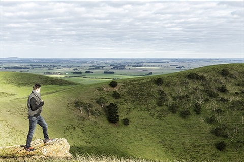
Mount Noorat is a major volcano of the Newer Volcanics Province of Victoria, with a peak height of 310 metres above sea level and a crater between 160 and 200 metres. It is characterised by multiple vents, a complex topography, and the deepest scoria enclosed crater in Victoria. The mount illustrates a transition from maar eruption to scoria cone development, and includes megacryst and xenolith.
The Mount was historically a traditional meeting and trading place for First Nations peoples, the Kirrae Wuurong, who exchanged stones, spears, skins and other material. Its scoria was used on the district's early roads.
In 2017, the Black family gifted the 146.5ha Mt Noorat site to Corangamite Shire so that it could be retained as a community asset in perpetuity. This was done in accordance with the wishes of the late Niel Black who had managed the Mt Noorat property since 1965 until his death in 2012. This generous contribution will ensure that Mt Noorat continues to be enjoyed by the community well into the future and is gratefully acknowledged by the Mt Noorat Management Committee and Corangamite Shire.
Mt Noorat is managed by a community Committee of Management. The Committee aims to continue to protect and enhance natural values, create quality visitor experiences that reflect the character of the site, ensure Aboriginal and European history is understood and respected, ensure walking tracks are accessible, well maintained and cater for diverse experiences and generate self-sustaining financial management and governance.
Mt Noorat Management Plan(PDF, 12MB)
Location
Morack Street, Noorat 3265 View Map
-38.1855416,142.935417
Morack Street ,
Noorat 3265
Morack Street ,
Noorat 3265
Mt Noorat Reserve